OpenLORIS-Scene Dataset
The software tools for collecting and processing data, and benchmarking have been released on GitHub: OpenLORIS-Scene Tools.
The OpenLORIS-Scene dataset aims to help evaluate the maturity of SLAM and scene understanding algorithms for real-world deployment, by providing visual, inertial and odometry data recorded with real robots in real scenes, and ground-truth robot trajectories acquired by motion capture system or high-resolution LiDARs. Multiple trajectories are provided for each scene, to capture scene changes caused by human activities, day-night shifts and other factors, which are crucial to address for long-term robot autonomy.
OpenLORIS is an open dataset. We welcome contribution of data from third parties. We can help with sensor setup, calibration, data collection and post-processing. Please contact Xuesong Shi for collaboration.
With OpenLORIS-Scene, we also set up a benchmark for lifelong SLAM. Please refer to the IROS 2019 Lifelong SLAM Challenge for a brief description of the benchmark and competition results.
More description of the datasets and benchmark can be found in this paper:
X Shi, D Li et al. “Are We Ready for Service Robots? The OpenLORIS-Scene Datasets for Lifelong SLAM.” International Conference on Robotics and Automation (ICRA), Paris, France, 2020, pp. 3139-3145.
@inproceedings{shi2019openlorisscene,
    title={Are We Ready for Service Robots? The {OpenLORIS-Scene} Datasets for Lifelong {SLAM}},
    author={Xuesong Shi and Dongjiang Li and Pengpeng Zhao and Qinbin Tian and Yuxin Tian and Qiwei Long and Chunhao Zhu and Jingwei Song and Fei Qiao and Le Song and Yangquan Guo and Zhigang Wang and Yimin Zhang and Baoxing Qin and Wei Yang and Fangshi Wang and Rosa H. M. Chan and Qi She},
    booktitle={2020 International Conference on Robotics and Automation (ICRA)},
    year={2020},
    pages={3139-3145},
}
Robot and Sensors
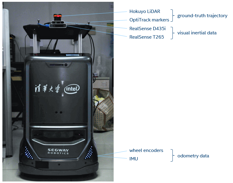
The data were collected by a wheeled robot moving at human walking speed or slower. The primary sensors include a RealSense D435i camera and a RealSense T265 camera, both mounted at a fixed height of about 1m. The color images and depth images from D435i are recommended for monocular/RGB-D algorithms, while the dual fisheye images from T265 are recommended for stereo algorithms. Both provide IMU measurements with hardware synchronization with corresponding images. Odometry data from wheel encoders are also be provided.
List of available data:
| device | data | FPS | resolution | FOV |
|---|---|---|---|---|
| D435i | color | 30 | 848x480 | H:69 V:42 D:77 |
| D435i | depth | 30 | 848x480 | H:91 V:65 D:100 |
| D435i | aligned deptha | 30 | 848x480 | H:69 V:42 D:77 |
| D435i | accel | 250 | - | |
| D435i | gyro | 400 | - | |
| T265 | fisheye1 | 30 | 848x800 | D:163 |
| T265 | fisheye2 | 30 | 848x800 | D:163 |
| T265 | accel | 62.5 | - | |
| T265 | gyro | 200 | - | |
| base | odom | 20b | - | |
| LiDAR | laser scan | 40 | 1080 | H:270c |
a Depth images aligned to color images for per-pixel correspondence. b This value is different for the market scene: 40. c This value is different for the market scene: H:360 V:30.
Ground-truth
The ground-truth trajectory of the robot is obtained by an OptiTrack motion capture system for the office scene, and from offline LiDAR SLAM based on the Hokuyo laser scans for other scenes.
Download
Fill this form to download the data.
The form is for us to track how many people are using the datasets, and to
contact with users when further data or related competitions are available.
Please leave the email field blank if you do not want to receive such emails.
The data can be downloaded from either Google Drive or Baidu Pan. See the urls and instructions on the download page.
Known Issues
- One depth image frame is missing in office1-6, at the time of 1560244316.03. (Thanks to Willyzw for identifying it)
Fixed Issues
If your data have the first three issues (meaning that they were downloaded between Nov 2019 and May 2020), you can fix them in place with the Python script fix_bags.py or fix_packages.py. (e.g. ./fix_bags.py --fix-all YOUR_OPENLORIS_FOLDER)
-
(Fixed in May 2020 release) The linear velocities in the odom data of office/corridor/home/cafe are in the world coordinates (odom frame, non-zero values on x and y directions) rather than the base coordinates (base_link frame, non-zero values on x-axis (forward) only).
-
(Fixed in May 2020 release) The first 9 data points in the ground-truth of home1-1 are unaligned with the remaining. Please remove them if that would be a concern. Please file an issue if you find similar problems in other data sequences.
-
(Fixed in May 2020 release) For all data, the noise factors of D435i IMU are not provided. An estimation of noise variances of D435i should be 0.0002678 for accel, and 1.0296e-5 for gyro. These values are derived from T265 noise factors scaled by their filter bandwidth.
-
(Fixed in Nov 2019 release) For office/corridor/cafe/home data, there is an translation error of over 1cm in the extrinsics of D435i IMU. The translation of d400_imu from d400_color should be [0.0203127935528755, -0.0051032523624599, -0.0112013882026076], while the current values are [0.014881294220686, -2.32995425903937e-05, 0.000588475959375501].
-
(Fixed in Nov 2019 release) There are duplicated messages on the /odom topic in office-1 bags. Can be removed with remove_duplicated_msgs.py.
FAQ
- Are all data synchronized?
Yes. The data from the same RealSense camera are hardware synchronized. Others are synchronized by software with a millisec level accuracy.
- Where are the intrinsics and extrinsics?
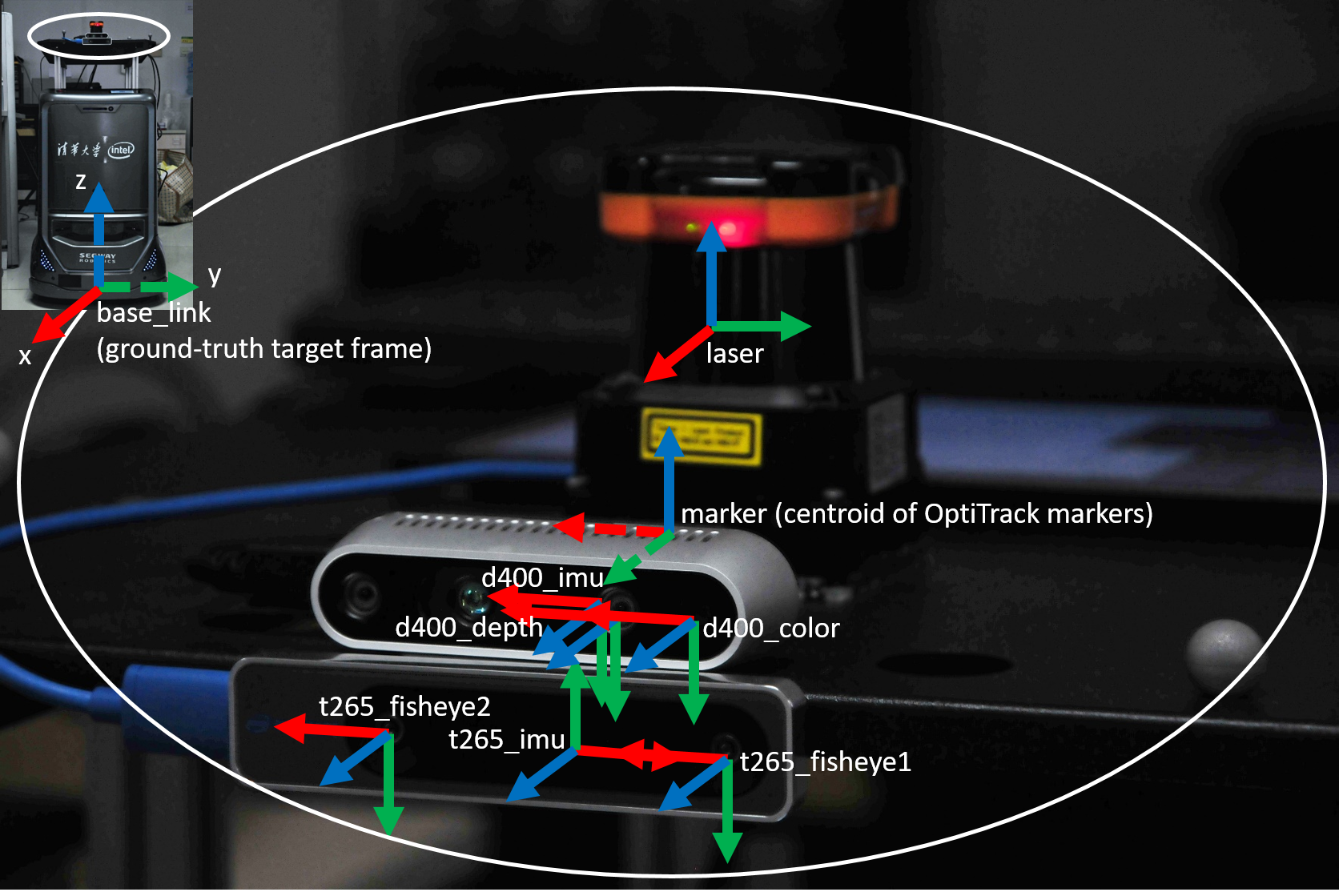
With the data. In the ROS bags, camera/IMU intrinsics are included in the camera_info/imu_info topics, extrinsics are in the tf_static topic.
- Can I assume identical intrinsics and extrinsics for all trajectories of the same scene?
Yes. For each scene the sensor setup are unchanged.
- How did you get the intrinsics and extrinsics?
All the intrinsics are from RealSense factory calibration (except for D435i IMU which was from official calibration procedure). Extrinsics are calibrated with various tools, as listed in the paper.
- What is the unit of the depth values?
The depth images from RealSense D435i are scaled by a factor of 1000. One may convert the uint16 values from depth images into float and multiply them by 0.001 to get depth values in meters.
- How to get ground-truth poses for each image?
The ground-truth values are derived from either mocap or laser measurements. They generally have different timestamps from the RealSense images. For each image, one may either use the ground-truth value with nearest timestamp, or interpolate between two nearest ones (e.g., to perform linear interpolation for position and Slerp for orientation).
- Why are there two sets of IMU data?
Both RealSense D435i and RealSense T265 has an integrated IMU (BMI055). Please choose the IMU data from the same device of your primary image source for better synchronization. Note that the two sets of IMU data have different axis directions.
- Why are there separate data for gyroscope and accelerometer? How to merge them?
We provide the raw data from the IMU, where the gyroscope and accelerometer have different data rates. You may merge them with linear interpolation or other advanced methods. A simple script for merging the two d400 IMU topics into a unified topic with linear interpolation can be found here.
- Are the IMU data calibrated?
No. Those are raw data from the sensor. You may want to apply the intrinsic matrix onto the data for better accuracy. The 12 values shall be treated as a 3x4 matrix with the left 3x3 block as a rotation matrix to rectify the axes, and the right 3x1 block as zero offsets. So the 3x4 matrix can be left multiplied to a homogeneous data point to give rectified data.
- What are the variances in IMU intrinsics?
They are the estimated variances of the noise and bias of the discrete measurements. The unit is (m/s2)2 for accel and (rad/s)2 for gyro. The values are from RealSense T265 factory calibration. They have a rough relation with the BMI055 datasheet values. For example, the sampling rate of accel in T265 is 62.5 Hz, implying a low-pass filtering bandwidth of 31.25 Hz. The BMI055 datasheet gives gyro noise density of 150μg/√Hz. So the thereotical value of T265 gyro noise variance is (150 * 1e-6 * 9.80665)2 * 31.25 = 6.76198014064453e-05. The given value is 6.695245247101411e-05.
- Can I get the exposure time of each image?
Yes. The exposure time is in header.seq of each image message in the ROS bags.
- Do the timestamps represent the true time of each recording?
No. Random biases have been added to the stamps.
Other questions? Please open an issue here. (please check the existing issues first)

